.png)

SECO Weather 7 Day Forecast April 23rd-29th 2026
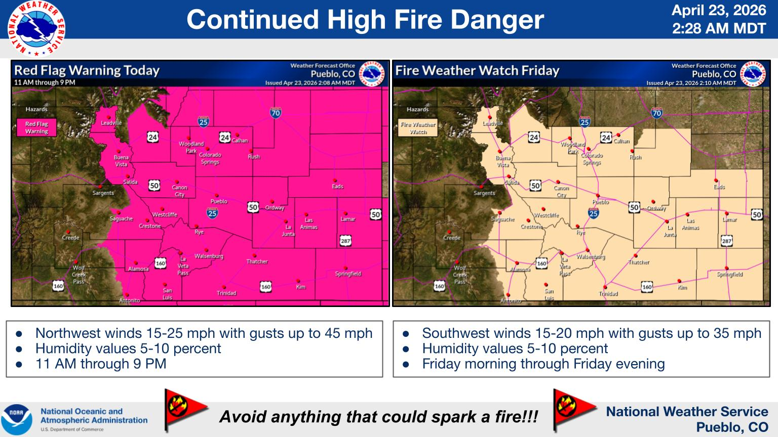
Description: Provided by Pueblo NWS
Today
Mostly cloudy through mid morning, then gradual clearing, with a high near 77. Northwest wind 5 to 15 mph becoming north northeast in the morning.
Tonight
Mostly clear, with a low around 36. North northwest wind 5 to 15 mph becoming west after midnight.
Friday
Sunny, with a high near 77. West wind 5 to 10 mph becoming south 10 to 15 mph in the afternoon.
Friday Night
Mostly cloudy, with a low around 40. South southeast wind 5 to 15 mph becoming west southwest after midnight. Winds could gust as high as 30 mph.
Saturday
Mostly sunny, with a high near 77. West wind 5 to 10 mph becoming east southeast 10 to 15 mph in the afternoon.
Saturday Night
A slight chance of showers and thunderstorms before 9pm, then a slight chance of showers after midnight. Mostly cloudy, with a low around 40. East wind 10 to 15 mph. Chance of precipitation is 20%. New precipitation amounts of less than a tenth of an inch, except higher amounts possible in thunderstorms.
Sunday
A chance of showers, with thunderstorms also possible after noon. Partly sunny, with a high near 79. Breezy, with an east wind 10 to 15 mph becoming west southwest 20 to 25 mph in the afternoon. Winds could gust as high as 35 mph. Chance of precipitation is 50%.
Sunday Night
A 30 percent chance of showers, mainly before midnight. Partly cloudy, with a low around 36. Breezy, with a west wind 15 to 25 mph, with gusts as high as 35 mph.
Monday
A 20 percent chance of showers and thunderstorms after noon. Sunny, with a high near 73. North wind around 10 mph.
Monday Night
Partly cloudy, with a low around 33. East wind 10 to 15 mph.
Tuesday
Sunny, with a high near 80. East southeast wind 10 to 15 mph.
Tuesday Night
Partly cloudy, with a low around 39. East northeast wind 10 to 15 mph.
Wednesday
A chance of showers. Mostly sunny, with a high near 76. Northeast wind 10 to 15 mph, with gusts as high as 30 mph.